Members can see more Boards, Topics, Picture Galleries, Videos, Games and more. Register NOW...
Recent Pictures (List All)

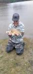
Rating: (None)
Views: 34
Comments (0)

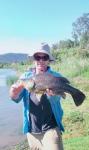
Rating: (None)
Views: 37
Comments (0)
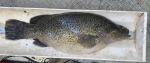
Rating: ****
Views: 37
Comments (4)

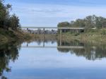
Rating: (None)
Views: 25
Comments (0)
*

Author Topic: Maybe the final word on Harpeng Road  (Read 17323 times)

0 Members and 1 Guest are viewing this topic.

Offline Member

  • Fish Restocker
  • Legend Member
  • *
  • Thank You
  • -Given: 420
  • -Receive: 1212
  • Posts: 3032
  • Liked: 104
  • Karma: 1242
  • Gender: Male
  • Sweetwater Fishing Larrikan
  • View Gallery
  • Favourite Fishing Spot is: Lake Wivenhoe, where else
Maybe the final word on Harpeng Road
« on: October 22, 2013, 07:25:54 AM »
This from DNRM
Quote
Harpeng Road, Wivenhoe Pocket

In January 2012, a temporary road closure application  for part of Harpeng Road was lodged because of environmental concerns and unauthorised access across the privately owned land - see Attachments 1 and 2 (Lot 3 on S31231 and Lot 55 on CC893).

A number of objections were received to the proposed road closure from the public. The basis of the objections was that the public had been using Harpeng Road to gain access to the Brisbane River for recreational activities for many years and there is no other access area for this stretch of river that is able to be used.  The existence of the fence obstructing access was also raised.

Somerset Regional Council objected to the road closure on the basis that the road was required for access to the river.

A number of letters supporting the proposed road closure were also received citing the damage caused to the riverbank by the public and untidy state of the site due to the rubbish left behind.

The application was refused in January 2013.

Due to the ongoing dispute regarding the existing fence reducing access to the river, departmental officers conducted an inspection of the site in on 14 June 2013 and found that:
-   there is an unlocked gate on Harpeng Road at the top of the bank.  The steep dirt track down the bank of the river would be treacherous in wet weather and difficult in the best of conditions to negotiate.  Access can be gained by foot. 
-   the fences constructed by the landowners appeared to be on the correct alignment as an extension of their fences along their properties boundary on Harpeng Road. 
-   landowners advised that people are cutting their fences and effectively trespassing on private property to find a less steep route down to the waters edge. 
-   due to the difficult terrain, vehicles become stuck on the bank and the public then seek assistance from the landowners.
-   the council can put a locked gate at the top of the bank for safety purposes under the Local Government Act and allow access to the river by foot only.
-   the current fence and gate provide a safety factor to stop people driving down the steep bank and then having difficulty getting back up again without trespassing on the adjoining properties.

On 18 June 2013, the department’s position was reconfirmed being:

1. Section 13A(4) of the Land Act 1994 (the Land Act), allows adjoining owners to a non-tidal boundary watercourse to exercise a right of access and grazing over the bed and banks of the adjoining boundary watercourse, therefore an adjoining owner may fence the riparian areas of the watercourse that adjoins the boundary of their land.
 
2. Harpeng Road extends to the Brisbane River watercourse boundary only and that the Somerset Regional Council has confirmed that the road does not extend across the watercourse to the road area adjoining Lot 55 on CC893.  It is the department's view that the fences within the bed and banks of the watercourse are in the appropriate location from the boundary of the adjoining lots (being Lot 3 on S31107 and Lot 115 on S31231) to Harpeng Road and that public access to the watercourse from Harpeng Road is available for fishing, recreational purposes. 
 
Where from here
There is ongoing contention that the adjoining owner should not / does not have the right to construct a fence across a watercourse which subsequently restricts the public’s access and use of the river.

Section13 A (4) (a) of the Land Act defines the ‘owner’ in terms of s20 (3) of the Water Act 2000 which defines who is authorised to take or interference with water without a water entitlement.  The general intent of s20 (3) is that the owner of land adjoining a watercourse has an as of right access to the water for stock and domestic purposes.

The Land Act then states that the ‘owner’ as defined by the Water Act may use this land for grazing secton 13(4) (b)  .

In the Harpeng Road case, the owners of Lot 3 on S31231 and Lot 55 on CC893 - have access rights for the entire width of the Brisbane River between their two properties. As the Land Act allows for grazing on this land, a fence that links the two parcels and prevents stock from straying outside the authorised area is considered reasonable and legal.

The Land Act also states under section 13(4) (c) that the owner may commence a trespass action against a person using this land. Therefore, the owners are entitled to commence trespass proceedings against any person using this land without their permission.

On face value, access to the Brisbane River along Harpeng Road still exists and based on the available imagery, the land between the owner’s properties does not appear to contain any actual water.


The Land Act does not allow for permits to occupy on non-tidal watercourses. However, in this context, the owners rights prevail in accordance with section 13 of the Land Act and no further authorisation is required.


Land Act 1994 - Division 3 The non-tidal environment

13A Land adjacent to non-tidal boundary (watercourse) or non-tidal boundary (lake) owned by State

(1) If land has a non-tidal boundary (watercourse), other land that adjoins the boundary and is on the watercourse side of the boundary is the property of the State.

(2) If land has a non-tidal boundary (lake), other land that adjoins the boundary and is on the lake side of the boundary is the property of the State.

(3) Subsections (1) and (2) apply despite the alienation of land by the State.

(4) A person (the owner) who may take water under the Water Act 2000, section 20(3)—
(a) may exercise a right of access for the owner, the owner’s family, executive officers, employees, agents and stock over the part (the adjacent area) of the watercourse or lake that is the property of the State and that adjoins the owner’s land; and

(b) may exercise a right of grazing for the person’s stock over the adjacent area; and

(c) may bring action against a person who trespasses on the adjacent area as if the owner were the registered owner of the adjacent area.

(5) If the adjacent area is being used by the State for a purpose under the Water Act 2000—
(a) subsection (4)(a) and (b) applies only to the extent exercising the right does not interfere with the State’s use of the adjacent area; and

(b) subsection (4)(c) does not allow the owner to bring an action against a person acting on behalf of the State.


Dale

I fish because the little voices in my head tell me to.

Offline Member

  • Hunter
  • Hero Member
  • *
  • Thank You
  • -Given: 8
  • -Receive: 89
  • Posts: 352
  • Liked: 4
  • Karma: 98
  • Gender: Male
  • Sweetwater Fishing Fanatic
  • View Gallery
  • Favourite Fishing Spot is: water
Re: Maybe the final word on Harpeng Road
« Reply #1 on: October 22, 2013, 07:42:56 AM »
So that is saying, the road access will remain open and as long as we stay on the path down, we are fine?

Offline Member

  • Fish Restocker
  • Legend Member
  • *
  • Thank You
  • -Given: 420
  • -Receive: 1212
  • Posts: 3032
  • Liked: 104
  • Karma: 1242
  • Gender: Male
  • Sweetwater Fishing Larrikan
  • View Gallery
  • Favourite Fishing Spot is: Lake Wivenhoe, where else
Re: Maybe the final word on Harpeng Road
« Reply #2 on: October 22, 2013, 08:13:31 AM »
In a nutshell, yes.  Stay between the fences.  Don't cut fences.  If you drive down, make sure you can drive back up as I doubt either of the landholders will tow you out and it would be costly to get the tow truck from Tarampa.
If you get out of your kayak, canoe or boat pretty much anywhere between Harpeng Road and Shines Road, and then upstream to the public access at the wall, you could be charged with trespass.

Offline Member

  • Newbie
  • *
  • Thank You
  • -Given: 1
  • -Receive: 1
  • Posts: 4
  • Liked: 0
  • Karma: 1
  • Gender: Male
  • Sweetwater Fishing Fanatic
  • View Gallery
  • Favourite Fishing Spot is: PNG
Re: Maybe the final word on Harpeng Road
« Reply #3 on: November 15, 2013, 10:25:43 AM »
Thanks for the info mate. Ive been told that as long as we stay within 3m of the 'shoreline' that we are not trespassing. Is that correct?

Offline Member

  • Fish Restocker
  • Legend Member
  • *
  • Thank You
  • -Given: 420
  • -Receive: 1212
  • Posts: 3032
  • Liked: 104
  • Karma: 1242
  • Gender: Male
  • Sweetwater Fishing Larrikan
  • View Gallery
  • Favourite Fishing Spot is: Lake Wivenhoe, where else
Re: Maybe the final word on Harpeng Road
« Reply #4 on: November 15, 2013, 10:58:01 AM »
Not sure what you mean by 3m of the shoreline.  At Harpeng Road you need to stay on the road reserve.  You cannot cross the fences downstream or upstream, you cannot walk up the riverbed or down the riverbed.  You cannot cross the river on foot.  You can float on the river once you get access to it although legally your kayak or boat should not touch the bottom of the riverbed.

Offline Member

  • Newbie
  • *
  • Thank You
  • -Given: 1
  • -Receive: 1
  • Posts: 4
  • Liked: 0
  • Karma: 1
  • Gender: Male
  • Sweetwater Fishing Fanatic
  • View Gallery
  • Favourite Fishing Spot is: PNG
Re: Maybe the final word on Harpeng Road
« Reply #5 on: November 15, 2013, 11:16:44 AM »
Sorry for the vagueness of my question. What i meant was that i have been told that you are allowed to walk the banks of the river even where the river is on private property (providing you gained access legally) as long as you don't stray further than 3 metres of the shoreline (which is hard to define with the change of water levels).

It seems as though you have answered my question and what i have been lead to believe was wrong. i guess that also means that dragging your yak over rocks/rapids counts as trespass as well? Thanks for clearing that up!

ps. i havent walked the banks on private property - im yak based - but just though id ask as there are times where it would be ideal to park up on the bank - ie lunch, re rigging etc

Offline Member

  • Fish Restocker
  • Legend Member
  • *
  • Thank You
  • -Given: 420
  • -Receive: 1212
  • Posts: 3032
  • Liked: 104
  • Karma: 1242
  • Gender: Male
  • Sweetwater Fishing Larrikan
  • View Gallery
  • Favourite Fishing Spot is: Lake Wivenhoe, where else
Re: Maybe the final word on Harpeng Road
« Reply #6 on: November 15, 2013, 11:34:34 AM »
You have been told incorrectly for Queensland.  Once you're on the river in your Yak, you cannot get out again unless you are at a public access point.

Offline Member

  • Sr. Member
  • ****
  • Thank You
  • -Given: 108
  • -Receive: 102
  • Posts: 165
  • Liked: 4
  • Karma: 104
  • Gender: Male
  • Sweetwater Fishing Fanatic
  • View Gallery
  • Favourite Fishing Spot is: Wivenhoe Dam
Re: Maybe the final word on Harpeng Road
« Reply #7 on: November 15, 2013, 12:20:01 PM »
As much as I hate the message, I thank the messenger.
Your efforts to clear it up are much appreciated.
cheers

Offline Member

  • Contributor
  • Legend Member
  • *
  • Thank You
  • -Given: 244
  • -Receive: 694
  • Posts: 922
  • Liked: 130
  • Karma: 704
  • Gender: Male
  • Unicorn Hunter
  • View Gallery
Re: Maybe the final word on Harpeng Road
« Reply #8 on: November 15, 2013, 04:47:58 PM »
The biggest issue of all is the problem with the annabranch just upstream. If one intends to travel down the river and goes via the annabranch ,with the log jam being so substantial , and the river bed so soft(in the shallow sections you will sink up to your waist), turning around is not really possible. The only real way to travel beyond Harpeng rd is to carry/drag your watercraft over the flood plain to bypass it. As the adjoining landholder claims trespass rights to this flood plain , legally you are up shite creek.

Someone will end up drowning in the annabranch and in my opinion the landholder, the Somerset council and those who administer the land act will be to blame. And a PFD will not save you in there either.

Offline Member

  • Lure Maker
  • Legend Member
  • **
  • Thank You
  • -Given: 414
  • -Receive: 233
  • Posts: 1225
  • Liked: 27
  • Karma: 233
  • Gender: Male
  • hunter
  • View Gallery
  • Favourite Fishing Spot is: oh somewhere out near the border ranges ....
Re: Maybe the final word on Harpeng Road
« Reply #9 on: November 15, 2013, 07:49:14 PM »
Has anyone thought to smack a warning sign on the entrance to the annabranch ?

Just putting a question others may ask out there

Offline Member

  • Fish Restocker
  • Legend Member
  • *
  • Thank You
  • -Given: 420
  • -Receive: 1212
  • Posts: 3032
  • Liked: 104
  • Karma: 1242
  • Gender: Male
  • Sweetwater Fishing Larrikan
  • View Gallery
  • Favourite Fishing Spot is: Lake Wivenhoe, where else
Re: Maybe the final word on Harpeng Road
« Reply #10 on: November 15, 2013, 08:02:29 PM »
I believe you may have to trespass to do that.

Offline Member

  • Full Member
  • ***
  • Thank You
  • -Given: 51
  • -Receive: 19
  • Posts: 96
  • Liked: 1
  • Karma: 23
  • Gender: Male
  • Sweetwater Fishing Fanatic
  • View Gallery
  • Favourite Fishing Spot is: colleges crossing
Re: Maybe the final word on Harpeng Road
« Reply #11 on: November 15, 2013, 08:57:43 PM »
Someone will end up drowning in the annabranch and in my opinion the landholder, the Somerset council and those who administer the land act will be to blame. And a PFD will not save you in there either.

Is it possible to petition the land owners or council to put a sign up since it could be a potential life threatening.

On the other hand It would be very rare to have some one paddling and not knowing about the log jam. Most people know about the log jam and the ones that don't would do some research before paddling if there smart.  Even if they do go down and have to walk on the bank it would take a real D head to charge them with trespassing.

cheers brad

Offline Member

  • Lure Maker
  • Legend Member
  • **
  • Thank You
  • -Given: 414
  • -Receive: 233
  • Posts: 1225
  • Liked: 27
  • Karma: 233
  • Gender: Male
  • hunter
  • View Gallery
  • Favourite Fishing Spot is: oh somewhere out near the border ranges ....
Re: Maybe the final word on Harpeng Road
« Reply #12 on: November 15, 2013, 08:59:21 PM »
Wouldnt have to get out of the kayak at all.

SO ill ask again .. :?)

Offline Member

  • Contributor
  • Legend Member
  • *
  • Thank You
  • -Given: 244
  • -Receive: 694
  • Posts: 922
  • Liked: 130
  • Karma: 704
  • Gender: Male
  • Unicorn Hunter
  • View Gallery
Re: Maybe the final word on Harpeng Road
« Reply #13 on: November 15, 2013, 09:06:36 PM »
Has anyone thought to smack a warning sign on the entrance to the annabranch ?

Just putting a question others may ask out there

Without a warning sign in some form, the lawyers will clean up taking every government authority to court. Because at the end of the day they are part of the reason this trap ( the anabranch situation ) exists.

At the opening to the annabranch it doesn't look that bad, the danger lies around the corner where its too late to back out.

The sign needs to direct people around the annabranch , but that requires access across the flood plain below Harpeng road. That means we are back at the beginning with the war against farmer Joe.

Offline Member

  • Contributor
  • Legend Member
  • *
  • Thank You
  • -Given: 244
  • -Receive: 694
  • Posts: 922
  • Liked: 130
  • Karma: 704
  • Gender: Male
  • Unicorn Hunter
  • View Gallery
Re: Maybe the final word on Harpeng Road
« Reply #14 on: November 15, 2013, 09:13:11 PM »
Also now that the Spillway Common has re-opened , it is a real possibility that someone who is very familiar with the river , will try a point to point down river paddle. Its only since the 2011 flood that the annabranch has been impossible to navigate. The spillway common at Atkinsons crossing has been closed since the 2011 flood, and as this is now the easiest launch site for recreational paddlers , the risk is real of someone unaware of the changes attempting the annabranch.


Related Topics

  Subject / Started by Replies Last post
17 Replies
16530 Views
Last post April 29, 2012, 08:51:58 AM
by Member
Harpeng Road Access Log

Started by Member « 1 2 ... 6 7 » Fishing Reports

97 Replies
49711 Views
Last post May 24, 2013, 12:38:27 PM
by Member
9 Replies
10219 Views
Last post September 03, 2012, 04:30:14 PM
by Member
5 Replies
5931 Views
Last post January 30, 2013, 07:00:36 AM
by Member
5 Replies
10586 Views
Last post October 28, 2015, 01:19:53 PM
by Member

Upcoming Events, Fishing Competitions, Shows, Expos etc.....


Upcoming Events