Members can see more Boards, Topics, Picture Galleries, Videos, Games and more. Register NOW...
Recent Pictures (List All)

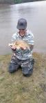
Rating: (None)
Views: 34
Comments (0)

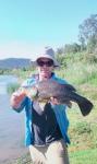
Rating: (None)
Views: 37
Comments (0)
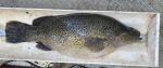
Rating: ****
Views: 37
Comments (4)

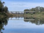
Rating: (None)
Views: 25
Comments (0)
*

Author Topic: Alpine Region Maritime Alert  (Read 2334 times)

0 Members and 1 Guest are viewing this topic.

Offline Member

  • Administrator
  • Legend Member
  • *****
  • Thank You
  • -Given: 2
  • -Receive: 369
  • Posts: 1728
  • Liked: 70
  • Karma: 376
  • Sweetwater Fishing Fanatic
  • View Gallery
Alpine Region Maritime Alert
« on: July 03, 2014, 12:34:58 PM »
Roads and Maritime Services advises skippers to be on alert on  Friday 04 July 2014 - NSW Maritime
Conditions tomorrow are expected to exceed Strong winds for the following locations:


3 Mile Dam Strong winds
Alpine Forecast
Snowy Mountains

Forecast for Friday 4 July. Partly cloudy. Morning frost. Isolated showers in the west during the evening, falling as snow above 1400 metres. Winds northwesterly 30 to 45 km/h.

Forecast for Saturday 5 July. Cloudy. Areas of morning frost, mainly in the east. The chance of showers, falling as snow above 1200 metres. Winds northwesterly 20 to 30 km/h turning westerly 15 to 20 km/h during the day.

Forecast for Sunday 6 July. Partly cloudy. Areas of morning frost, mainly in the north. Areas of morning fog. The chance of showers, falling as snow above 1300 metres. Winds west to southwesterly 15 to 20 km/h becoming light during the afternoon.

Issued at 04:31 PM AEST on Wednesday 02 July 2014 for the period until midnight AEST on Sunday 06 July 2014.


Googong Dam (near Canberra) Strong winds

Alpine Forecast
Southern Tablelands

Forecast for Friday 4 July. Areas of fog in the northwest early in the morning. Morning frost. Mostly sunny day. The chance of showers in the northwest at night. Winds west to northwesterly 25 to 40 km/h. Overnight temperatures falling to between minus 2 and 1 above zero with daytime temperatures reaching between 9 and 12.

Forecast for Saturday 5 July. Partly cloudy. Areas of morning frost in the east. The chance of showers in the northwest. Winds west to northwesterly 20 to 30 km/h. Overnight temperatures falling to between zero and 3 with daytime temperatures reaching between 8 and 12.

Forecast for Sunday 6 July. Partly cloudy. Areas of frost and patchy fog in the southeast in the morning. The chance of drizzle in the northwest until evening. Winds westerly 15 to 25 km/h becoming light during the afternoon. Overnight temperatures falling to between zero and 4 with daytime temperatures reaching between 9 and 12.

Issued at 04:30 PM AEST on Wednesday 02 July 2014 for the period until midnight AEST on Sunday 06 July 2014.


Burrinjuck Strong winds
Alpine Forecast
Southern Tablelands

Forecast for Friday 4 July. Areas of fog in the northwest early in the morning. Morning frost. Mostly sunny day. The chance of showers in the northwest at night. Winds west to northwesterly 25 to 40 km/h. Overnight temperatures falling to between minus 2 and 1 above zero with daytime temperatures reaching between 9 and 12.

Forecast for Saturday 5 July. Partly cloudy. Areas of morning frost in the east. The chance of showers in the northwest. Winds west to northwesterly 20 to 30 km/h. Overnight temperatures falling to between zero and 3 with daytime temperatures reaching between 8 and 12.

Forecast for Sunday 6 July. Partly cloudy. Areas of frost and patchy fog in the southeast in the morning. The chance of drizzle in the northwest until evening. Winds westerly 15 to 25 km/h becoming light during the afternoon. Overnight temperatures falling to between zero and 4 with daytime temperatures reaching between 9 and 12.

Issued at 04:30 PM AEST on Wednesday 02 July 2014 for the period until midnight AEST on Sunday 06 July 2014.


Eucumbene Strong winds
Alpine Forecast
Snowy Mountains

Forecast for Friday 4 July. Partly cloudy. Morning frost. Isolated showers in the west during the evening, falling as snow above 1400 metres. Winds northwesterly 30 to 45 km/h.

Forecast for Saturday 5 July. Cloudy. Areas of morning frost, mainly in the east. The chance of showers, falling as snow above 1200 metres. Winds northwesterly 20 to 30 km/h turning westerly 15 to 20 km/h during the day.

Forecast for Sunday 6 July. Partly cloudy. Areas of morning frost, mainly in the north. Areas of morning fog. The chance of showers, falling as snow above 1300 metres. Winds west to southwesterly 15 to 20 km/h becoming light during the afternoon.

Issued at 04:31 PM AEST on Wednesday 02 July 2014 for the period until midnight AEST on Sunday 06 July 2014.


Blowering Strong winds
Alpine Forecast
Snowy Mountains

Forecast for Friday 4 July. Partly cloudy. Morning frost. Isolated showers in the west during the evening, falling as snow above 1400 metres. Winds northwesterly 30 to 45 km/h.

Forecast for Saturday 5 July. Cloudy. Areas of morning frost, mainly in the east. The chance of showers, falling as snow above 1200 metres. Winds northwesterly 20 to 30 km/h turning westerly 15 to 20 km/h during the day.

Forecast for Sunday 6 July. Partly cloudy. Areas of morning frost, mainly in the north. Areas of morning fog. The chance of showers, falling as snow above 1300 metres. Winds west to southwesterly 15 to 20 km/h becoming light during the afternoon.

Issued at 04:31 PM AEST on Wednesday 02 July 2014 for the period until midnight AEST on Sunday 06 July 2014.


Geehi Dam Strong winds
Alpine Forecast
Snowy Mountains

Forecast for Friday 4 July. Partly cloudy. Morning frost. Isolated showers in the west during the evening, falling as snow above 1400 metres. Winds northwesterly 30 to 45 km/h.

Forecast for Saturday 5 July. Cloudy. Areas of morning frost, mainly in the east. The chance of showers, falling as snow above 1200 metres. Winds northwesterly 20 to 30 km/h turning westerly 15 to 20 km/h during the day.

Forecast for Sunday 6 July. Partly cloudy. Areas of morning frost, mainly in the north. Areas of morning fog. The chance of showers, falling as snow above 1300 metres. Winds west to southwesterly 15 to 20 km/h becoming light during the afternoon.

Issued at 04:31 PM AEST on Wednesday 02 July 2014 for the period until midnight AEST on Sunday 06 July 2014.


Jindabyne Strong winds

Alpine Forecast
Snowy Mountains

Forecast for Friday 4 July. Partly cloudy. Morning frost. Isolated showers in the west during the evening, falling as snow above 1400 metres. Winds northwesterly 30 to 45 km/h.

Forecast for Saturday 5 July. Cloudy. Areas of morning frost, mainly in the east. The chance of showers, falling as snow above 1200 metres. Winds northwesterly 20 to 30 km/h turning westerly 15 to 20 km/h during the day.

Forecast for Sunday 6 July. Partly cloudy. Areas of morning frost, mainly in the north. Areas of morning fog. The chance of showers, falling as snow above 1300 metres. Winds west to southwesterly 15 to 20 km/h becoming light during the afternoon.

Issued at 04:31 PM AEST on Wednesday 02 July 2014 for the period until midnight AEST on Sunday 06 July 2014.


Talbingo Dam Strong winds
Alpine Forecast
Snowy Mountains

Forecast for Friday 4 July. Partly cloudy. Morning frost. Isolated showers in the west during the evening, falling as snow above 1400 metres. Winds northwesterly 30 to 45 km/h.

Forecast for Saturday 5 July. Cloudy. Areas of morning frost, mainly in the east. The chance of showers, falling as snow above 1200 metres. Winds northwesterly 20 to 30 km/h turning westerly 15 to 20 km/h during the day.

Forecast for Sunday 6 July. Partly cloudy. Areas of morning frost, mainly in the north. Areas of morning fog. The chance of showers, falling as snow above 1300 metres. Winds west to southwesterly 15 to 20 km/h becoming light during the afternoon.

Issued at 04:31 PM AEST on Wednesday 02 July 2014 for the period until midnight AEST on Sunday 06 July 2014.


Tantangara Dam Strong winds
Alpine Forecast
Snowy Mountains

Forecast for Friday 4 July. Partly cloudy. Morning frost. Isolated showers in the west during the evening, falling as snow above 1400 metres. Winds northwesterly 30 to 45 km/h.

Forecast for Saturday 5 July. Cloudy. Areas of morning frost, mainly in the east. The chance of showers, falling as snow above 1200 metres. Winds northwesterly 20 to 30 km/h turning westerly 15 to 20 km/h during the day.

Forecast for Sunday 6 July. Partly cloudy. Areas of morning frost, mainly in the north. Areas of morning fog. The chance of showers, falling as snow above 1300 metres. Winds west to southwesterly 15 to 20 km/h becoming light during the afternoon.

Issued at 04:31 PM AEST on Wednesday 02 July 2014 for the period until midnight AEST on Sunday 06 July 2014.


Tooma Reservoir Strong winds
Alpine Forecast
Snowy Mountains

Forecast for Friday 4 July. Partly cloudy. Morning frost. Isolated showers in the west during the evening, falling as snow above 1400 metres. Winds northwesterly 30 to 45 km/h.

Forecast for Saturday 5 July. Cloudy. Areas of morning frost, mainly in the east. The chance of showers, falling as snow above 1200 metres. Winds northwesterly 20 to 30 km/h turning westerly 15 to 20 km/h during the day.

Forecast for Sunday 6 July. Partly cloudy. Areas of morning frost, mainly in the north. Areas of morning fog. The chance of showers, falling as snow above 1300 metres. Winds west to southwesterly 15 to 20 km/h becoming light during the afternoon.

Issued at 04:31 PM AEST on Wednesday 02 July 2014 for the period until midnight AEST on Sunday 06 July 2014.


Tumut Pondage Strong winds
Alpine Forecast
Snowy Mountains

Forecast for Friday 4 July. Partly cloudy. Morning frost. Isolated showers in the west during the evening, falling as snow above 1400 metres. Winds northwesterly 30 to 45 km/h.

Forecast for Saturday 5 July. Cloudy. Areas of morning frost, mainly in the east. The chance of showers, falling as snow above 1200 metres. Winds northwesterly 20 to 30 km/h turning westerly 15 to 20 km/h during the day.

Forecast for Sunday 6 July. Partly cloudy. Areas of morning frost, mainly in the north. Areas of morning fog. The chance of showers, falling as snow above 1300 metres. Winds west to southwesterly 15 to 20 km/h becoming light during the afternoon.

Issued at 04:31 PM AEST on Wednesday 02 July 2014 for the period until midnight AEST on Sunday 06 July 2014.


Sunrise: 07:01 AM.
Sunset: 04:58 PM.

Times above are adjusted for Daylight Savings when appropriate.


Sweetwater Fishing Home http://www.sweetwaterfishing.com.au


Related Topics

  Subject / Started by Replies Last post
4 Replies
5817 Views
Last post November 06, 2010, 01:04:52 AM
by Member
0 Replies
2987 Views
Last post November 20, 2013, 11:09:49 AM
by Member
0 Replies
2658 Views
Last post December 20, 2013, 01:24:40 PM
by Member
0 Replies
2776 Views
Last post January 03, 2014, 11:48:02 AM
by Member
0 Replies
3038 Views
Last post December 12, 2014, 08:04:52 AM
by Member

Upcoming Events, Fishing Competitions, Shows, Expos etc.....


Upcoming Events