Brisbane
River Bass Fishing - Lake Wivenhoe to Bremer River Junction
THE
lure landed with a splash just a bit louder than what I would
have prefered but landed nicely just next to a snag that was
angling down into the water. Directly over head a mixture
of bottle brush and mulberry tree and a higher canopy of river
gums were blocking out the early morning sun. Everything seemed
perfect for a big season openning session.
The
water looked great, perfect weather & two keen anglers.
As the water settled and the rings dissipated I twitched
the lure once, then twice as the anticipation and excitement
of the surface strike that was I was sure was just about
to happen. The lure was then slowly retrieved the 30 odd
feet back to the rod tip without so much of a nudge. The
next few throws resulted in the same response as the first,
with the melody of a kookaburra in the background laughing
it seemed, directly at me.
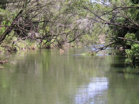
The
area had changed a bit since the last visit to the spot on
the Mid-Brisbane River, but with a few decent flows through
the system earlier in the year the fish could be holding anywhere.
This particular location had yielded plenty of bass last summer
right up to the closed season but at this time the section
of water that normally held good numbers of fish was barren.
Following
the once plentiful section of river along until it widened
out to a broad stretch of deeper, slower moving river,
a well presented cast was snaffled right next to the first
snag in a cast that was simply lucky enough to get in
under the overhanging trees and make it to that lazy backwater
they were hiding.
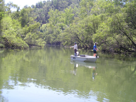
We
had found a large school of all 40-cm plus bass holding
close to the bottom in 20 feet of water. In previous years
a legal sized bass (30cm) would be an above average fish
but the thing stripping off my 6 pound line was in a different
class all of it's own, causing both my partner and I to
both call it as a fork tailed catfish. Pulling it along
side the boat it became obvious that this mid 40 something
cm bass was not one of the remnant population of fish
that are normally here. A 30 minute frenzy of cast, catch
& release prevailed until the fish got wise to us
and we moved on in search of more action.
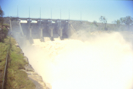
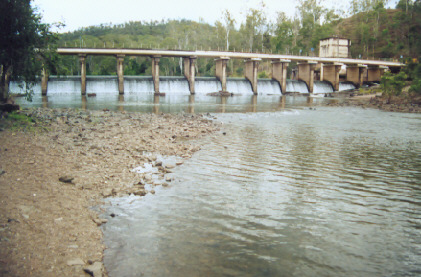
History
With the heavy rains in the summer of 1999/2000 and the
subsequent opening of the floodgates at Lake Wivenhoe,
a fair number of fish stocked into Wivenhoe and Somerset
now reside in the 60 kilometres of river down to the tidal
reaches near Ipswich. Fish up to and over the magical
60 cm mark have and still are being caught along this
section of the Brissy to the point where even inexperienced
young fishos can go out and get amongst them without too
much effort. These large fat females are used to plenty
of food in their old environment and are now more than
happy to have a go at anything that swims past them as
food is a lot scarcer for them now.
Catches
of up to 20 and 30 in a session are common place around the
areas where public access is allowed, namely down stream from
the Mt. Crosby weir. *Note that there is a total ban on
fishing 200m above and 400m below Mt. Crosby weir, which is
approximately down to the old weir. This should possibly be
extended further downstream as bass are schooling up just
below the old weir (which the fish have trouble getting through
as well as the main weir) and it would be quite fair to say
that an unfair advantage exists for fisherman in this situation.
The same can be said for the section of water directly below
Lakes Wivenhoe and Somerset where a few people have been caught
exceeding their bag limit.
As
a lot of the stocked bass in the upstream lakes have been
originally bred from Noosa River strain fish it would be fair
to say that there is and/or will be a mixed gene pool of fish
here. And as Noosa bass tend to spawn earlier than most other
strains the question begs to be asked if the two strains will
be in the same place at the same time come next spawning season.
There well may be some remnant fish here that have grown to
these sizes but to give you some indication of growth rates
a bass in the river may take eight to ten years to reach the
legal size of 30 cm, a bit over 12 months in lake Wivenhoe
will see the same size achieved.
It
must be remembered that bass have been stocked into lakes
on regular basis for around 15 years now. It seems that not
all of these liberated fish are reverting to their natural
riverine habits. Many are being found schooling up in the
deeper sections of the river some in open water all day and
at night. Wild bass tend to stay under the cover of overhanging
trees and around submerged logs during the day and venture
out to hunt in the open water and shallows at night. Some
things noted on some of these bigger fish were sores, cuts
and a few split tails, further evidence of their passage through
the floodgates.
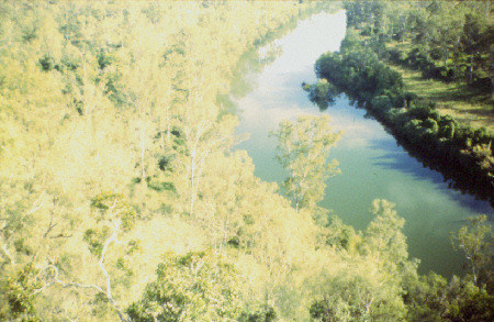
The
Brisbane River is roughly formed into three sections.
- The
Lower-Brisbane River being the tidal reaches from the mouth
upto below Mt Crosby Weir.
-The
Mid-Brisbane River is approximately 60 km from Mt Crosby Weir
upto Lake Wivenhoe.
-The Upper-Brisbane River is from the top of Lake Wivenhoe
at O'Sheas Crossing right up to the headwaters meandering
through the Esk Shire up past Linville.
Apart from the lower reaches, access is possible at numerous
bridges, culverts and reserves both in the mid & upper
reaches if the river. While boating is possible, these two
small-water sections of the river a best explored by canoe
or kayak. There are many pristine sections of the river that
probably haven't changed much since Capt. Logan first explored
this great river.
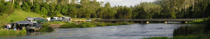
Locations
There are several access points to go fishing on the mid &
lower Brisbane River available to the public with all other
access, permission is required by landowners for entry.
These are:
1-
Lake Wivenhoe spillway common (when open) This area has
a no fishing zone extending 600m from the base of the
dam wall. Reasonable bank access here. About a 50m walk
from the carpark to the water. Suitable starting point
for a canoe/kayak trip. Gates are locked here at sundown.
No camping.
2-
Shines Road. Wivenhoe Pocket. The river can be accessed via
the road / recreation reserve at the end of Shines Rd. This
is not recomended as a river access point as there is a very
steep hill to negotiate and a sheer drop off at water level.
No facilities provided.
3-
Harpeng Road. This is probably one of the most important
access point to the mid Brisbane River. Since the 1940s
this has been a popular access point for family recreation
activities, canoeing, fishing and swimming. It offers gently
sloping banks and shallow water; the only safe canoe launching
point from the log jam upstream. Until recently boats could
be launched here to be able to access the long holes upstream,
however some over zealous local land owners have fenced the
road reserve blocking the long time access to boats, thus
canoes / kayaks are currently the only viable option unfortunately.
The main flow of the river goes via the anabranch on the opposite
site of the privately owned island. The anabranch narrows
up here & the water velocity increases as it approaches
a massive log jam. DO NOT ATTEMPT
TO KAYAK DOWN THE ANABRANCH AS IT IS VERY DANGEROUS.
To get past this dangerous log jam you need to portage along
the shingle crossing at the Harpeng Road reserve. No facilities
provided.
4-
The Bends on the road between Fernvale and Lowood. This spot
is immedaitely off the road between Fernvale & Lowood.
A steep dirt track leading down to the water is suitable for
4x4s only. Limited bank walking area. A good canoe launching
site. No facilities to speak of.
5
- Twin Bridges. This is the old river crossing west of
Fernvale on the Brisbane Valley Highway, a popular starting
point for camping canoeing trips down the river. Small
boats can be launched both above & below the bridges
with care. Camping is allowed & can be a popular location
on weekends. Toilets are provided on both sides of the
river.
6-
Savages Crossing. Popular camping spot. This spot is right
in the middle of shallow rapids. A good swimming location
& fairly safe for kids. It is possible to launch a small
boat here, however there is little navagable water with more
serious rapids immediately above and below. Large area for
bank walking however not a very productive fishing location
at most times.
7-
Burton's Bridge. A small access spot. Virtually impossible
to launch a boat here. Canoes can be carried down yo to the
waters edge. Long, shallow fast water immediately below the
bridge make paddling back up difficult.
7a
- There is also occasional access a couple of kilometers
downstream via private property. Depending upon the recent
form of visitors, public access may be allowed or denied.
A good stretch of bank that holds the occasional fish.
No vehicle access now-a-days so its a couple hundred meters
walk to the river when public access is allowed.
8-
Kholo Bridge. (No further public access is allowed between
Kholo bridge and Mt.Crosby weir) A popular swimming location
for Ipswich locals. Usually the pick-up point for (normally
2 days unless you're Grant Kenny) river long canoe/kayak trips.
9-
Mt Crosby weir. (No fishing 200m above and 400m below
main weir). Some good fishing downstream at times. The
Old weir approx 800- 1000m below the main weir is disused
but has a 50m no fish zone on the dowstream side. Further
down are mid-stream boulders that hold fish at times.
Alot of area for bank walking and canoeing. A short paddle
of less than an hour will see even a novice paddler arrive
at Colleges Crossing. Toilets on west bank side near weir
and at nearby cricket field.
10-
College's Crossing. Ipswich. Tidal flows through this area.
Popular picnic and canoeing area. A boat ramp exists but is
for canoe use only. Kiosk and toilet facilities. A regular
haunt for anglers chasing gar, mullet, bull sharks and the
occasional bream and bass.
11-
Kookaburra park. Karana Downs. Tidal. A popular skiers area.
All upstream boating is limited to six knots maximum. Upstream
travel from here can be hazardous around Johnson's Rocks.
Use extreme caution. Toilets. Bass can be caught at all these
locations with relative ease depending on weather patterns
and water flow.
Bream,
Flathead, Tarpon and Sharks are common captures at College's
Crossing and Kookaburra Park at certain times of the year.
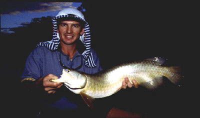
Other species present are Golden Perch, Silver Perch, Mary
River Cod, Saratoga, Mullet, Spangled Perch, Eel Tailed Catfish
(Jew), Fork Tailed Catfish, Eels, Snub Nosed Gar, Tilapia
and Lungfish which are totally protected. Some of the country
along the upper Brisbane River is in pristine condition. Platypus,
snakes and birds are a common sight in some of the quieter
areas. Please leave this river as it was before your visit
and future generations may also enjoy the beauty and quality
fishing that is on offer.