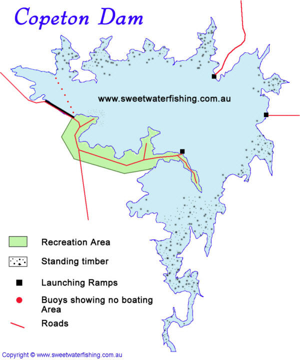
Located
approx 30km South West of Inverell is Copeton Dam also called
Copeton Waters.
Lake Copeton is almost three times the size of Sydney Harbour
when full. The dam was built across the Gwydir River in
1976 and its primary use is for irrigation
water storage. When water is being released, the lake levels
can drop dramatically which has the effect of putting fish
off the bite.
Fishing
Copeton Dam is renown as a top Murray Cod, Golden Perch,
Silver Perch, Redfin & Eel-Tailed Catfish fishery with
possibly a remnant trout from past stockings.
Rainbow Trout are still taken in Gwydir River downstream
of Copeton Dam.
Upstream of the lake is some pristine gorge country that
holds the odd Cod & Yellowbelly. It is rugged country
being more suited to goats (which there are alot in the
area) than to people but can be rewarding at times for those
that are keen & fit enought to traverse the boulders
and cliffs. The river below the Dam holds some trout &
is also a popular white water rafting location during water
releases.
Stocked
fish: Murray Cod, Golden Perch and Silver Perch.
Boating
There are no boating restrictions on Copeton Dam. A no boating
zone exists around the dam wall.
There are several boat launching areas around the lake.
The best depends upon the water level at any given time.
The
main recreation area, Copeton Waters State Park, is located
on the southern side of the lake. The park covers 939 hectares
where campers can enjoy a free form style of camping. There
are hot showers and amenities blocks (disabled facilities)
scattered throughout the park. A kiosk and laundry are also
within the park and there are 76 powered camping/caravan
sites. Cabins, on-site vans, fuel sales and boats are also
available for hire. Other facilities include BBQ, six hole
golf course, tennis courts, adventure playgrounds, power
boating, sailing, windsurfing and two waterslides.
On the northern side is the (aptly named) Northern Foreshores
Reserve. This area of Copeton Dam is located 17 km south
of the town. Offering picnic and BBQ areas, amenities block
with hot showers, powered sites, and camping areas, boat
ramp and fish cleaning table. A playground is also located
in the reserve. Fishing, water skiing, sailing and camping
are also available. There is a resident caretaker on-site.


